|
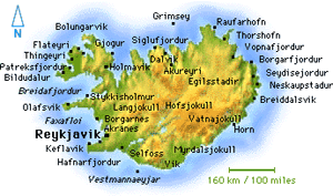
REYKJAVIK
Iceland’s cosmopolitan little capital is site of some of Europe’s best nightlife.
THE BLUE LAGOON
Is it blue like the sky? Like the new M&M’s? You decide.
GEYSIR
It is the one, the only, and the original geyser after which all other geysers are named.
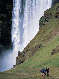
GULLFOSS
Europe’s largest waterfall is one of Iceland’s great treasures, the mystical embodiment of the nation’s soul.
AKUREYRI
If you think it’s cold here, think again. Iceland’s northern capital is the place where Reykjavikers head for some sun.
THINGVELLIR
Just over a thousand years ago, the world’s first parliament was held in this extraordinary natural amphitheater – which sits smack in the middle of the Mid-Atlantic
Ridge.
SNAEFELLSNES PENINSULA
There are Sagas hidden in the landscape of the Snaefellsness Peninsula and, according to Jules Verne, the gateway to the center of the Earth.
LAKE MYVATN
Lake Myvatn, in North Iceland, is surrounded by a landscape so otherworldly that Apollo astronauts came here to learn how to moonwalk.
WESTMANN ISLES
The world’s youngest archipelago, often called "the Galapagos of the North," is an ecological wonderland.
|